Monday, May 28, 2012

Sun Tunnels

Here's a satellite view of a random spot in the Utah desert.

Well...maybe not so random. There is something unusual in the middle of the photo. Here's a closer look...
Can't tell what it is? Here's a ground level view...

Still confused? It should be obvious by now. Clearly, this is four sections of enormous concrete pipe arrayed in an X-pattern...
It's the sort of thing you see every day when wandering around in the desert. That's Ron inside. I'm standing on a raised marker at the crossing of the X-pattern in the pic below.
These pipes are not light; it took some effort to get them out here and "properly aligned". So...why would someone do this? Ask Nancy Holt.


Wednesday, May 16, 2012

AN/FLR-9 at San Vito, Italy

In late March, 1986, I traveled with a co-worker to San Vito "Air Station" (i.e. staffed mostly by Air Force personnel, but no runways anywhere around). San Vito is near Brindisi, Italy; we were there to do a site survey pertaining to the installation of some equipment. What I remember most about this trip was that we arrived a day or two after the Navy sailed across the "line of death" into the Gulf of Sidra and mixed it up with Libyan strongman Col.Muammar Gaddafi. We were in Greece immediately before the visit to San Vito, so we flew from Athens to Rome (on Olympic Airways) en route to Brindisi. The Rome airport had been attacked by terrorists a mere three months earlier.  Within a day or two after we got back to the US, 4 Americans were killed when a bomb exploded on a TWA flight from Rome to Athens. For those of you who think terrorism (and aviation terrorism in particular) is a recent historical development...think again; this was 26 years ago. I did not get combat pay for this trip, but I did have some lousy pizza at Lecce, Italy (no tomato sauce), got caught in a semi-riot at a security checkpoint in Paris DeGaulle Airport, and flew Air France for the one and only time in my life (Paris to Houston). But these incidents are not visible from space; the San Vito FLR-9 antenna site is. The antenna was decommissioned when the US abandoned the base in 1993, no longer necessary with the end of the Cold War.

AN/FLR-9 antenna at San Vito Air Station, Italy [40 38 51N, 17 50 25E]

Sunday, May 13, 2012

AN/FLR-9 at Elmendorf AFB, Alaska

Alaska was always on the front line of our Cold War defenses, for obvious proximity reasons. Much of the military activity was controlled from Elmendorf AFB in Anchorage, the largest city in Alaska (but not the capital). The base was built in 1940, becoming a forward outpost relatively close to Japan. I traveled to Elmendorf several times in the mid-80s, and on one occasion, I visited the facility adjacent to the AN/FLR-9 antenna. Recent satellite imagery suggests the building is still in use...perhaps the antenna as well.


AN/FLR-9 antenna at Elmendorf AFB, Alaksa [61 15 52N, 149 51 04W]

Friday, May 11, 2012

Studebaker

For those of you too young to know about such things...Studebaker was an automobile manufacturer based in South Bend, Indiana. The company went defunct in the early 1960s. At the site of their automotive "proving grounds", they left some trees behind...

Studebaker Proving Grounds near South Bend, Indiana [41 40 07N, 86 29 27W]

Thursday, May 10, 2012

Karamursel, Turkey AN/FLR-9

The US had a long and important military relationship with Turkey during the Cold War due to its proximity to the Soviet Union. Thus, it is not surprising that there are many relics of that relationship visible from space. One of them is the former FLR-9 antenna site at Karamursel, near Istanbul. Karamursel's location on the Bay of Izmit has resulted in it serving as a base for various navies at least since 1327. (I don't think the US was involved back then.) The US operated a base here for many years, but pulled out for good in 1979 (though the handwriting was on the wall in July, 1975 when the Turkish government demanded an immediate shutdown of the base in response to a US arms embargo). The FLR-9 is long gone, but the circular vegetation patterns continue to mark the location.

FLR-9 site at Karamursel, Turkey [40 42 35N, 29 31 39E]

Sunday, May 6, 2012

Lake Kickapoo, TX Transmitter

In the mid-90s, while on a railroad history field trip to investigate the remnants of a rail line that once ran through Olney, Texas, I was surprised to see a small sign with an arrow referencing some cryptic sort of US Navy facility. Olney is well inland, so it wouldn't have anything to do with the floating Navy, and there were no airports in the area, certainly nothing the flying Navy would use. The implication was some sort of radar or other surveillance system. Sure enough, the Navy had built a transmitter site for the Navy Space Surveillance System near Lake Kickapoo. Interestingly, the transmitter is two miles long and actually crosses a farm road. Reportedly, the Navy transferred management of this system to the Air Force and presumably it remains in operation. Wikipedia claims this is the most powerful Continuous Wave transmitter in the world, generating 768 kW of continuous radiated power at 216.983 MHz. Guess I'll need to tune my UHF radio at the office to this frequency and see what's there.
US Navy Spasur Transmitter, Lake Kickapoo, Texas [33 33 09N, 98 45 47W]
Even more interesting, this farm road has been tracked with Google Street View, as shown below (looking north from the crossing)

Clark AB, Philippines

In October, 1985 I traveled to Clark Air Base, Philippines. What I remember most about that trip was being deathly ill with high fever when I began the trip at DFW Airport on an early evening flight to San Francisco, where I connected to a Philippine Airways overnight flight to Manila. By the time we refueled in Honolulu around 2:00 am, I didn't have the strength to even bother to get off the plane during the 90-minute stopover. Aspirin kept me lucid enough to clear passport and customs in Manila at dawn on a Sunday. Many of the streets in downtown were closed that morning for the Manila Marathon, or somesuch race. The driver dispatched by the Hyatt Regency to pick me up at the airport was available for hire, so I arranged for him to drive me to Clark AB on Monday morning. I spent the rest of Sunday in bed, suffering jet lag and high fever. We departed for Clark before dawn Monday to avoid the horrible city traffic (I still recall the "Stay in Your Lane" banners hanging from various overpasses -- and yes, they were in English, the official language for business, at least, it was in 1985). Best I recall, it was a 2 or 3 hours drive. I still had the fever when I checked into the Visiting Officer's Quarters at Clark, and I went promptly to bed, turning on the radio to listen to the Dallas Cowboys vs. New York Giants game on Armed Forces Radio, a Sunday night game (October 6th) in the US. I napped off and on during the game, but when I awoke for good, I knew I was delirious: The Giants, needing only to kneel down for a couple of snaps to run out the clock and preserve a 2 point victory, inexplicably ran a handoff play and fumbled, with the Cowboys recovering. Rafael Septien kicked a field goal to win the game for the Cowboys, 30-29. My fever broke at the same time. I was never a big Cowboys fan -- still not -- but it can be a good way to pass the time by radio, even in the Philippines.  But I digress...

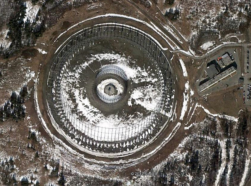
Clark AB had hosted a FLR-9 antenna since April, 1965, and it was easily spotted as we drove around the base. I do not know if it was dismantled before the US pulled out of Clark rather suddenly in 1991. The Mt. Pinatubo volcano erupted in March and virtually wiped out the base. Rather than rebuild (and with the base lease having expired), the US abandoned the facility and it became dormant looting grounds for many years. Eventually, the Philippine government went in and redeveloped the facility. In doing so, they definitely won the prize for "Best Redevelopment of a FLR-9 Antenna Site". It's called Clark Expo, home of the Nayong Pilipino Historic and Cultural Amusement Park. The site also includes an exhibition center. The distinctive circular arrangement is unmistakable; even the outer ring antenna pole locations were reused.

FLR-9 Site at Clark AB, Philippines [15 12 18N, 120 31 39E]

Eldorado

PAVE PAWS radar near Eldorado, Texas [30 58 42N, 100 33 10W]


PAVE PAWS is a military radar network designed to detect ballistic missiles heading toward the US. Since this would include submarine-launched missiles, the network has to look in directions you might not immediately think of when pondering the likely launch areas for ICBMs. The Gulf of California and the Gulf of Mexico, for example. To satisfy that requirement, a PAVE PAWS radar site was built in southwest Texas near the town of Eldorado. The triangular shape of the radar allows for two arrays facing southwest and southeast.

As can be seen from the image, weeds growing in the parking lot and no vehicles in sight is a sure sign that this facility is no longer operational (reportedly shut down in the mid-90's).


But perhaps they should have restarted it a few years ago so they could spy on their neighbors to the south. Mexico? No...I'm referring to the Yearning For Zion (YFZ) Ranch less than four miles south-southeast of the radar. This is the Fundamentalist Latter Day Saints compound that became famous in recent years because of the raid by law enforcement officers resulting in various prosecutions and court proceedings in nearby San Angelo for polygamy and related offenses. See http://en.wikipedia.org/wiki/FLDS for details...

In the image at left, the PAVE PAWS radar site is visible at upper left and the YFZ Ranch compound is the maze of roads and buildings at the bottom. On a recent drive down US 277, it was easy to spot the radar, but I did not notice the YFZ compound. It may not be visible from the highway...at the time, I didn't actually know where to look.

Artesian Belt Railroad

Artesian Belt Railroad ROW near Somerset, Texas [29 12 41N, 98 38 24W]

The Artesian Belt Railroad is a long forgotten railroad that operated south of San Antonio, Texas a century ago. How it was started and its ultimate demise made a sufficiently interesting story that I co-wrote an article about it. The article was published in Clearance Card, the quarterly journal of the Southwest Railroad Historical Society. Getting it published was easy since I was the editor of Clearance Card. SRHS is no longer the historical society that it once, was having morphed into a vagabond railroad museum. My involvement ceased a decade ago. If Clearance Card is still published, it is likely a museum newsletter. Fortunately, the article we wrote is available on my co-author's website here http://codney.tnorr.com/simmons.htm.

Saturday, May 5, 2012

Shemya Island

Cobra Dane [52 44 14N, 174 05 30E]
The Cobra Dane Radar is located on Shemya Island, Alaska. It's a phased-array radar approximately 95 ft. in diameter facing northwest toward the Russian missile ranges near Kamchatka. Shemya is both pretty and bleak. My first visit was in July, 1985. It was sunny and 57F when we landed -- I was promptly told that this was one of the half-dozen days of sunshine they would have each year (and I never saw the sun again for the remainder of the week, nor on a subsequent trip in December). It was also one of the warmest (with 63F claimed as the all-time high temperature on the island). I also saw a few bluebonnets and lots of blue foxes. Hard to believe bluebonnets would grow under those conditions, but they did. I had been told about the blue foxes by my grandfather, Julian Bullock, a Navy Seabee who had built the first runway on Shemya during WWII. Turns out that the foxes had become tame over the years from being around people (once the island became a military base during WWII). The first sight I saw as I went down the back stairs of the Reeve Aleutian Airways 727 Combo (freight and passengers) was a blue fox looking up the stairway. During the week, I got a tour of the Cobra Dane Radar facility. They had me sign their guestbook for "official visitors". The most recent visitor (from the prior week) had been William J. Casey.

original runway on Shemya Island...new one at lower right

CDAA at Bondville, IL

So...you're driving aimlessly around the countryside near Bondville, Illinois and you stumble upon these land-scars. They are the remnants of the original Wullenweber array built (or, more precisely, "reassembled" from a dismantled German antenna) by the University of Illinois for HF direction finding research after WWII. The term "Wullenweber" reportedly derives from the German code name for their Circular Disposed Antenna Array (CDAA) research during the war. Not sure what the square area was, but it has signs of having hosted antenna research of some kind.  [40 02 59N, 88 22 51W]

FLR-9 at Augsburg, Germany

I visited Augsburg in August, 1985. This Google Earth image shows that the FLR-9 appears to still be intact. Don't know if it's actually being used any more.  [48 27 05N, 10 51 46E]

FLR-9 at RAF Chicksands

Many circular antenna arrays have been built around the world, almost all of them for military purposes. I have visited a few of these sites. I believe the first one I ever saw (in 1982) was this one at RAF Chicksands, UK. Its military nomenclature was AN/FLR-9, but most people just called it a "Flair 9". It's been dismantled, but the land-scar will be there for a long time... [52 02 39N, 00 23 21W]   Below is a ground level photo I took in October, 1982

Getting Started

I'm intrigued by satellite imagery, particularly of locations with telltale signs of what is, or what used to be, something unusual. As I began to use satellite imagery in my website that documents Texas railroad towers, http://www.towers.txrrhistory.com/index.htm, I started looking for other things of interest. On this blog, I plan to post images from space that I find interesting.