Friday, July 20, 2012

Scientology

So...how do you view Scientology from space? Good question, but not really the intent of this post. Recently I happened to read the Wikipedia page about L. Ron Hubbard, the founder of Scientology. Seems like Scientology has been in the news a bit more recently, and I was curious about whatever happened to him. I still remember all the TV commercials from my college and early adult years advertising his book Dianetics. Sounded interesting and benign...those advertising people are slick...but I digress. Anyway, the article states that the last two years of his life was spent living in a motorhome parked on a 160-acre ranch he owned (or perhaps..."controlled", since he was living in "deep hiding"). The ranch was near Creston, California and the article has an oblique aerial photo of it. Having never heard of Creston, I decided to find out where it's located and see if I could spot the ranch. And here it is...!

2011 view of the ranch [35 27 13N, 120 30 07W]

When looking at this image, I was curious as to what the double diamond construction in the oval might represent, but then I noticed the imagery date was 2011. Hubbard died in 1986, so the ranch may not have looked quite like this at the time. Google has historical imagery dating to 1994...and that imagery looks considerably different.
1994 view of the ranch [35 27 13N, 120 30 07W]


Saturday, June 30, 2012

Clarity Tunnel

The geography of Texas has historically resulted in the need for very few railroad tunnels. The vast amount of land with relatively few natural obstacles meant that construction could usually go around a potential tunnel, even in central and west Texas where most of the hills are located. But this was not always true; by all accounts, there have been six railroad tunnels constructed in Texas, none of which are still in use for rail traffic. [And I'm talking "real" tunnels, not "urban" tunnels or subways (e.g. the DART tunnel in Dallas) where tracks have been placed below ground.] Two of the tunnels were along the Ft. Worth & Denver South Plains Railway, a branch line of the Ft. Worth & Denver Railway. The line was constructed from Estelline to Dimmitt, a distance of 131 miles, in 1927-28, primarily to serve the cotton business near Lubbock and Plainview. The longer of the two tunnels was Clarity Tunnel, a curved tunnel 742 feet in length named for F. E. Clarity, a member of the railroad's Board of Directors. I do not know the name of the other tunnel, but it was much smaller and located a short distance west of Clarity Tunnel. The story goes that a train derailed in the smaller tunnel, and in the process of cleaning up the mess, the railroad decided to eliminate the tunnel by "daylighting" it, i.e. excavating it so that the tunnel no longer existed. Clarity Tunnel remained in use until the rail line was abandoned in 1989. In the early 90's, the Texas Parks & Wildlife Department converted the abandoned right-of-way into the Caprock Canyons Trail between Estelline and South Plains which includes the section encompassing Clarity Tunnel. It's a great bike ride (or on horseback, if you prefer).
Vicinity of Clarity Tunnel [34 14 22N, 101 07 30W]

Saturday, June 16, 2012

Alternate Stonehenge

Since my wife is visiting England at the moment, it seems like an appropriate time to look at Stonehenge from space. Compared to the nearby parking lot, it doesn't seem as large as I expected.

Stonehenge [51 10 44N, 1 49 34W]


The original purpose of Stonehenge was always a mystery...until British and US scientists figured it out a few years ago. When they solved the riddle of Stonehenge, they were so shocked by the incredible power of their discovery that it immediately became a National Defence Secret, critical to military objectives of the Western World, to be revealed only to those with "need to know". The US wanted immediately to secure the Stonehenge site and ban the Public, fearing that when the secret eventually leaked out, anarchists would try to destroy the site. The British refused, concerned about making it such an obvious Security target. The US then decided it was best to build an Alternate Stonehenge at a secret location. Thus, if the real Stonehenge is destroyed, the Alternate Stonehenge can take its place and continue to serve Strategic Defense Objectives with its classified power. Although I cannot reveal its location, I can personally confirm that the Alternate Stonehenge exists, having visited the site in recent years. The stones were carefully replicated to match the layout of the original site, but of course, they are not as eroded as the original stones, and some of the fallen stones were righted (so as to improve the fidelity of the operation).

Alternate Stonehenge

I even managed to smuggle out a photo taken at ground level.


Figuring that such photos would eventually surface, the US Military built a fake Home Depot in the background as a means of confusing enemy imagery analysts. (They considered building a fake Starbucks or McDonalds, but were concerned that due to the small size of those buildings, they would not be clearly visible in a smuggled, ground level photo.) So...rest assured that the power of Stonehenge is being protected. And if you happen to know the location of Alternate Stonehenge, please contact me so I can pass your name to the Authorities.


Sunday, June 10, 2012

Robert Smithson

Spiral Jetty [41 26 16N, 112 40 08W]

Nancy Holt, creator of the Sun Tunnels, was married to an earthworks artist, Robert Smithson. Not far from the location of the Sun Tunnels, Smithson created an earthwork called the Spiral Jetty in 1970 along the north shore of the Great Salt Lake. I've never made it out there, but it would be an amusing side trip if visiting the Golden Spike area again. Turns out that Smithson died at age 35 in a plane crash while surveying a site for an earthwork to be called Amarillo Ramp. His wife implemented his design for Amarillo Ramp at a small, private lake northwest of Amarillo, Texas. Like many bodies of water in the Texas panhandle, the lake disappears during times of drought. But Amarillo Ramp is still visible 39 years after it was built.

Amarillo Ramp [35 22 31N, 102 01 48W]

Monday, May 28, 2012

Sun Tunnels

Here's a satellite view of a random spot in the Utah desert.

Well...maybe not so random. There is something unusual in the middle of the photo. Here's a closer look...
Can't tell what it is? Here's a ground level view...

Still confused? It should be obvious by now. Clearly, this is four sections of enormous concrete pipe arrayed in an X-pattern...
It's the sort of thing you see every day when wandering around in the desert. That's Ron inside. I'm standing on a raised marker at the crossing of the X-pattern in the pic below.
These pipes are not light; it took some effort to get them out here and "properly aligned". So...why would someone do this? Ask Nancy Holt.


Wednesday, May 16, 2012

AN/FLR-9 at San Vito, Italy

In late March, 1986, I traveled with a co-worker to San Vito "Air Station" (i.e. staffed mostly by Air Force personnel, but no runways anywhere around). San Vito is near Brindisi, Italy; we were there to do a site survey pertaining to the installation of some equipment. What I remember most about this trip was that we arrived a day or two after the Navy sailed across the "line of death" into the Gulf of Sidra and mixed it up with Libyan strongman Col.Muammar Gaddafi. We were in Greece immediately before the visit to San Vito, so we flew from Athens to Rome (on Olympic Airways) en route to Brindisi. The Rome airport had been attacked by terrorists a mere three months earlier.  Within a day or two after we got back to the US, 4 Americans were killed when a bomb exploded on a TWA flight from Rome to Athens. For those of you who think terrorism (and aviation terrorism in particular) is a recent historical development...think again; this was 26 years ago. I did not get combat pay for this trip, but I did have some lousy pizza at Lecce, Italy (no tomato sauce), got caught in a semi-riot at a security checkpoint in Paris DeGaulle Airport, and flew Air France for the one and only time in my life (Paris to Houston). But these incidents are not visible from space; the San Vito FLR-9 antenna site is. The antenna was decommissioned when the US abandoned the base in 1993, no longer necessary with the end of the Cold War.

AN/FLR-9 antenna at San Vito Air Station, Italy [40 38 51N, 17 50 25E]

Sunday, May 13, 2012

AN/FLR-9 at Elmendorf AFB, Alaska

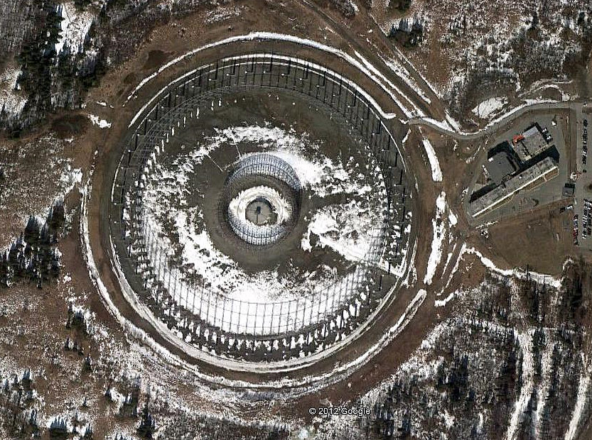
Alaska was always on the front line of our Cold War defenses, for obvious proximity reasons. Much of the military activity was controlled from Elmendorf AFB in Anchorage, the largest city in Alaska (but not the capital). The base was built in 1940, becoming a forward outpost relatively close to Japan. I traveled to Elmendorf several times in the mid-80s, and on one occasion, I visited the facility adjacent to the AN/FLR-9 antenna. Recent satellite imagery suggests the building is still in use...perhaps the antenna as well.


AN/FLR-9 antenna at Elmendorf AFB, Alaksa [61 15 52N, 149 51 04W]